About APEKS
APEKS (Shanghai Apekstool) is a leading provider of advanced geospatial surveying and mapping solutions. With customers in 60+ countries and over 41,500 active users, we deliver reliable GNSS/GPS systems, total stations, levels, and complete Ready-To-Survey packages.
Location
Unit No. 821, 8th Floor,
Jaina Tower-1, District Centre,
Janakpuri, New Delhi - 110058
India
Follow Us
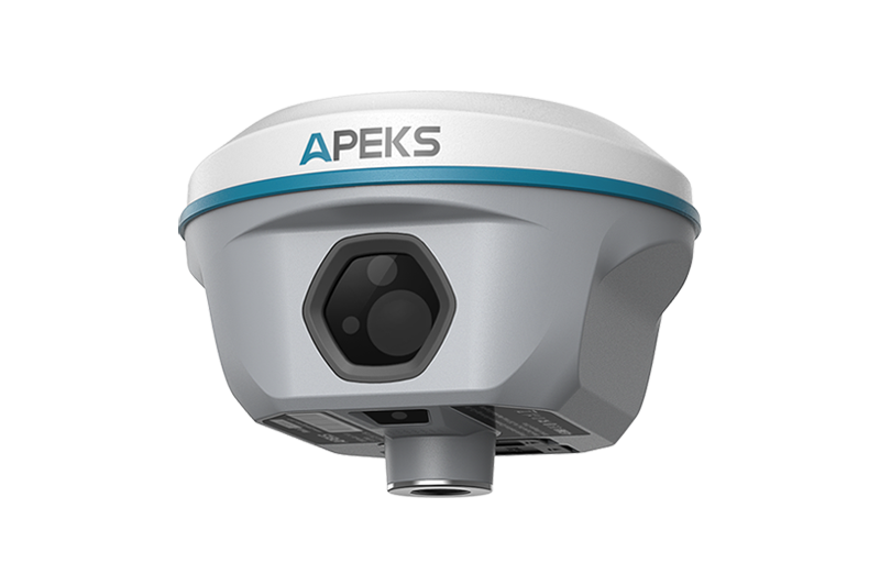
AP10 GNSS Receiver


Navigate with Precision – Efficiency Meets Affordability
Brand
Apeks GNSSDistributor
Trivision Tech (India)Technology
1408-Channel GNSS + 120° IMU Tilt CompensationOverview
The AP10 GNSS is a powerful and cost-effective professional-grade GNSS receiver featuring a built-in 2W UHF modem (8–15 km working range). It is perfect for base station or rover applications. With up to 120° tilt IMU, the built-in tilt sensor increases surveying efficiency by up to 30%. It delivers highly productive RTK performance for surveying and stakeout in any topographic, mapping, or construction site application.
Key Product Features
- 1408 channels – All constellation & frequency tracking
- Up to 120° IMU tilt compensation (accuracy <2cm within 60°)
- Built-in 2W UHF Tx/Rx radio – 8–15 km range
- IP67 dust & waterproof + rugged magnesium alloy body
- 9000 mAh high-capacity battery – all-day operation
- Supports NTRIP, RTCM 3.x, CMR – base/rover flexible
- Web UI management + firmware upgrade via WiFi
What We Provide
 AP10 GNSS Receiver (Rover/Base)
- CS3i Android Rugged Data Controller
- ApekSurv Professional Field Software (Android)
- Full India Warranty & Local Support by Trivision Tech
- Web UI Management & Cloud Firmware Updates
- Complete Accessories Kit (Carbon Pole, Charger, UHF Antenna)
Data Controller – CS3i
Rugged Android 11 handheld with sunlight-readable 5.5" display, IP68 rating, 9000 mAh battery, 4G/WiFi/Bluetooth, physical keypad, and full ApekSurv software pre-installed.
ApekSurv Field Software
Fully featured surveying software supporting CAD/DXF import, direct stakeout, multiple base maps (Google, WMS), coordinate system management, and seamless data export in all major formats.
Solution & Results
The AP10 combines cutting-edge 1408-channel GNSS tracking with an ultra-reliable 120° IMU tilt sensor, reducing the need for precise leveling and increasing daily productivity by up to 30%. The integrated 2W radio allows long-range base-rover operation without external radios. Ideal for land surveying, construction layout, cadastral work, and GIS data collection across India.